
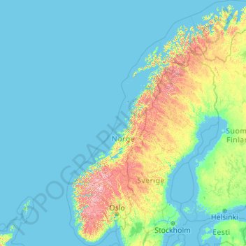
Norway topographic map
Interactive map
Click on the map to display elevation.
About this map
Name: Norway topographic map, elevation, terrain.
Location: Norway (57.75901 4.08753 71.38488 31.76149)
Average elevation: 469 ft
Minimum elevation: -10 ft
Maximum elevation: 7,438 ft
At 385,207 square kilometres (148,729 sq mi) (including Svalbard and Jan Mayen; 323,808 square kilometres (125,023 sq mi) without), much of the country is dominated by mountainous or high terrain, with a great variety of natural features caused by prehistoric glaciers and varied topography. The most noticeable of these are the fjords. Sognefjorden is the world's second deepest fjord, and the world's longest at 204 kilometres (127 mi). Hornindalsvatnet is the deepest lake in Europe. Norway has about 400,000 lakes and 239,057 registered islands. Permafrost can be found all year in the higher mountain areas and in the interior of Finnmark county. Numerous glaciers are found in Norway. The land is mostly made of hard granite and gneiss rock, but slate, sandstone, and limestone are also common, and the lowest elevations contain marine deposits.
Other topographic maps
Click on a map to view its topography, its elevation and its terrain.
Rauland
Rauland, Vinje, Vestfold og Telemark, Norway
Average elevation: 2,497 ft
Havøysund - Ávanuorri
Havøysund - Ávanuorri, Måsøy, Troms og Finnmark, 9690, Norway
Average elevation: 230 ft
Dyrstad
Dyrstad, Ibestad, Troms og Finnmark, 9450, Norway
Average elevation: 203 ft
Rotsund - Guohcanuorri - Nuora
Rotsund - Guohcanuorri - Nuora, Nordreisa, Troms og Finnmark, Norway
Average elevation: 620 ft
Bjørnevatn
Bjørnevatn, South Varanki, Troms og Finnmark, 9910, Norway
Average elevation: 269 ft
Vinje
Norway > Møre og Romsdal > Geiranger
Vinje, Geiranger, Stranda, Møre og Romsdal, 6216, Norway
Average elevation: 1,844 ft
Bloomberg
Bloomberg, Stranda, Møre og Romsdal, Norway
Average elevation: 1,073 ft
Vinjane
Norway > Vestland > Aurlandsvangen
Vinjane, Aurlandsvangen, Aurland, Vestland, 5745, Norway
Average elevation: 758 ft
Vesle Vålåsjå
Vesle Vålåsjå, Tinn, Vestfold og Telemark, Norway
Average elevation: 3,839 ft
Raudnesvika naturreservat
Raudnesvika naturreservat, Sula, Møre og Romsdal, Norway
Average elevation: 610 ft
Treungen
Treungen, Nissedal, Vestfold og Telemark, 3855, Norway
Average elevation: 1,171 ft