
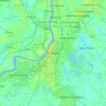
Kolkata topographic map
Interactive map
Click on the map to display elevation.
About this map
Name: Kolkata topographic map, elevation, terrain.
Location: Kolkata, Kolkata District, West Bengal, 700073, India (22.41265 88.20390 22.73265 88.52390)
Average elevation: 16 ft
Minimum elevation: -7 ft
Maximum elevation: 69 ft
Spread roughly north–south along the east bank of the Hooghly River, Kolkata sits within the lower Ganges Delta of eastern India approximately 75 km (47 mi) west of the international border with Bangladesh; the city's elevation is 1.5–9 m (5–30 ft). Much of the city was originally a wetland that was reclaimed over the decades to accommodate a burgeoning population. The remaining undeveloped areas, known as the East Kolkata Wetlands, were designated a "wetland of international importance" by the Ramsar Convention (1975). As with most of the Indo-Gangetic Plain, the soil and water are predominantly alluvial in origin. Kolkata is located over the "Bengal basin", a pericratonic tertiary basin. Bengal basin comprises three structural units: shelf or platform in the west; central hinge or shelf/slope break; and deep basinal part in the east and southeast. Kolkata is located atop the western part of the hinge zone which is about 25 km (16 mi) wide at a depth of about 45,000 m (148,000 ft) below the surface. The shelf and hinge zones have many faults, among them some are active. Total thickness of sediment below Kolkata is nearly 7,500 m (24,600 ft) above the crystalline basement; of these the top 350–450 m (1,150–1,480 ft) is Quaternary, followed by 4,500–5,500 m (14,760–18,040 ft) of Tertiary sediments, 500–700 m (1,640–2,300 ft) trap wash of Cretaceous trap and 600–800 m (1,970–2,620 ft) Permian-Carboniferous Gondwana rocks. The quaternary sediments consist of clay, silt, and several grades of sand and gravel. These sediments are sandwiched between two clay beds: the lower one at a depth of 250–650 m (820–2,130 ft); the upper one 10–40 m (30–130 ft) in thickness. According to the Bureau of Indian Standards, on a scale ranging from I to V in order of increasing susceptibility to earthquakes, the city lies inside seismic zone III.
Other topographic maps
Click on a map to view its topography, its elevation and its terrain.
Mandirbazar
Mandirbazar, South 24 Parganas District, West Bengal, 743336, India
Average elevation: 13 ft
Nabagram
Nabagram, Murshidabad District, West Bengal, India
Average elevation: 79 ft
Balughata
India > West Bengal > Haldia
Balughata, Haldia, Purba Medinipur District, West Bengal, 721666, India
Average elevation: 10 ft
Sonada
India > West Bengal > Jorebunglow Sukiapokhri
Sonada, Jorebunglow Sukiapokhri, Darjeeling District, West Bengal, 734102, India
Average elevation: 5,896 ft
Jorebunglow Sukiapokhri
Jorebunglow Sukiapokhri, Darjeeling District, West Bengal, India
Average elevation: 5,220 ft
Ilam Bazar
India > West Bengal > Illambazar
Ilam Bazar, Illambazar, Birbhum District, West Bengal, 731214, India
Average elevation: 190 ft
Sriniketan
India > West Bengal > Bolpur Sriniketan
Sriniketan, Bolpur Sriniketan, Birbhum District, West Bengal, 731235, India
Average elevation: 174 ft
Bolpur
India > West Bengal > Bolpur Sriniketan
Bolpur, Bolpur Sriniketan, Birbhum District, West Bengal, India
Average elevation: 164 ft
Bolpur Sriniketan
Bolpur Sriniketan, Birbhum District, West Bengal, India
Average elevation: 138 ft
Diamond Harbour - II
Diamond Harbour - II, South 24 Parganas District, West Bengal, 743368, India
Average elevation: 10 ft
Kalimpong -I
Kalimpong -I, Kalimpong District, West Bengal, India
Average elevation: 2,703 ft
Alipurduar
India > West Bengal > Alipurduar - I
Alipurduar, Alipurduar - I, Alipurduar District, West Bengal, 736121, India
Average elevation: 177 ft
Chalsa
India > West Bengal > Matiali
Chalsa, Matiali, Jalpaiguri District, West Bengal, 735206, India
Average elevation: 607 ft
Rajpur Sonarpur
India > West Bengal > Sonarpur
Rajpur Sonarpur, Sonarpur, South 24 Parganas District, West Bengal, 700150, India
Average elevation: 13 ft
Bhangar - I
Bhangar - I, South 24 Parganas District, West Bengal, 743502, India
Average elevation: 10 ft
Jaynagar Majilpur
India > West Bengal > Jaynagar - I
Jaynagar Majilpur, Jaynagar - I, South 24 Parganas District, West Bengal, 743337, India
Average elevation: 16 ft
Kultali
Kultali, South 24 Parganas District, West Bengal, India
Average elevation: 10 ft
Ghoramara
India > West Bengal > Islampur
Ghoramara, Islampur, Uttar Dinajpur District, West Bengal, 733202, India
Average elevation: 203 ft
Paschim Medinipur District
Paschim Medinipur District, West Bengal, India
Average elevation: 112 ft
Manteswar
Manteswar, Purba Bardhaman District, West Bengal, India
Average elevation: 52 ft
Darjeeling Pulbazar
Darjeeling Pulbazar, Darjeeling District, West Bengal, India
Average elevation: 5,837 ft
Mayurakshi
India > West Bengal > Bharatpur - I
Mayurakshi, Bharatpur - I, Murshidabad District, West Bengal, India
Average elevation: 66 ft
Bally
India > West Bengal > Bally Jagachha
Bally, Bally Jagachha, Howrah, West Bengal, 712258, India
Average elevation: 20 ft
Faridpur Durgapur
Faridpur Durgapur, Paschim Bardhaman, West Bengal, India
Average elevation: 262 ft
Gangani - The Grand Canyon Of Bengal
India > West Bengal > Garbeta-I
Gangani - The Grand Canyon Of Bengal, Garbeta-I, Paschim Medinipur, West Bengal, 721127, India
Average elevation: 151 ft
Siliguri
India > West Bengal > Matigara block
Siliguri, Matigara block, Darjeeling district, West Bengal, India
Average elevation: 397 ft
Jiaganj Azimganj
India > West Bengal > Murshidabad Jiaganj
Jiaganj Azimganj, Murshidabad Jiaganj, Murshidabad, West Bengal, 742123, India
Average elevation: 72 ft
Bidhannagar
Bidhannagar, North 24 Parganas District, West Bengal, India
Average elevation: 16 ft
Durgapur
India > West Bengal > Faridpur Durgapur
Durgapur, Faridpur Durgapur, Paschim Bardhaman District, West Bengal, 713200, India
Average elevation: 249 ft
Sandakphu
India > West Bengal > Darjeeling Pulbazar
Sandakphu, Darjeeling Pulbazar, Darjeeling district, West Bengal, India
Average elevation: 10,778 ft
Ashoknagar Kalyangarh
India > West Bengal > Habra - II
Ashoknagar Kalyangarh, Habra - II, West Bengal, 743222, India
Average elevation: 23 ft
Shantipur
India > West Bengal > Santipur
Shantipur, Santipur, Nadia, West Bengal, 741404, India
Average elevation: 36 ft
Jhalda - I
Jhalda - I, Puruliya, West Bengal, 723202, India
Average elevation: 1,024 ft
Cooch Behar
India > West Bengal > Cooch Behar
Cooch Behar, Kochbihar, West Bengal, India
Average elevation: 135 ft
Bardhaman
India > West Bengal > Burdwan - I
Bardhaman, Burdwan - I, Purba Bardhaman District, West Bengal, India
Average elevation: 102 ft
Mandarmani
India > West Bengal > Ramnagar-II
Mandarmani, Ramnagar-II, Purba Medinipur, West Bengal, India
Average elevation: 7 ft
Arambagh
India > West Bengal > Arambag
Arambagh, Arambag, Hooghly District, West Bengal, 712600, India
Average elevation: 56 ft
Kurseong
India > West Bengal > Kurseong Subdivision
Kurseong, Kurseong Subdivision, Darjeeling District, West Bengal, 734203, India
Average elevation: 3,698 ft
Jalpaiguri
Jalpaiguri, Jalpaiguri District, West Bengal, India
Average elevation: 266 ft