
Pallavaram topographic map
Interactive map
Click on the map to display elevation.
About this map
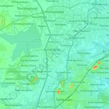
Name: Pallavaram topographic map, elevation, terrain.
Location: Pallavaram, Chengalpattu District, Tamil Nadu, India (12.93671 80.04518 13.04060 80.20399)
Average elevation: 69 ft
Minimum elevation: 3 ft
Maximum elevation: 472 ft
Other topographic maps
Click on a map to view its topography, its elevation and its terrain.
Tiruneermalai
India > Tamil Nadu > Pallavaram
Tiruneermalai, Pallavaram, Chengalpattu District, Tamil Nadu, 600092, India
Average elevation: 62 ft