
Hopkinton topographic map
Interactive map
Click on the map to display elevation.
About this map
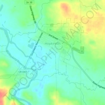
Name: Hopkinton topographic map, elevation, terrain.
Location: Hopkinton, Delaware County, Iowa, United States (42.33286 -91.26164 42.35056 -91.23750)
Average elevation: 883 ft
Minimum elevation: 820 ft
Maximum elevation: 1,010 ft
Other topographic maps
Click on a map to view its topography, its elevation and its terrain.
Ryan
United States > Iowa > Delaware County
Ryan, Delaware County, Iowa, United States
Average elevation: 1,017 ft
Delaware
United States > Iowa > Delaware County
Delaware, Delaware County, Iowa, 52036, United States
Average elevation: 1,056 ft
Colesburg
United States > Iowa > Delaware County
Colesburg, Delaware County, Iowa, United States
Average elevation: 1,132 ft
Greeley
United States > Iowa > Delaware County
Greeley, Delaware County, Iowa, United States
Average elevation: 1,138 ft
Delhi
United States > Iowa > Delaware County
Delhi, Delaware County, Iowa, United States
Average elevation: 1,050 ft
York
United States > Iowa > Delaware County
York, Delaware County, Iowa, United States
Average elevation: 1,115 ft
Dundee
United States > Iowa > Delaware County
Dundee, Delaware County, Iowa, United States
Average elevation: 1,020 ft
Backbone State Park
United States > Iowa > Delaware County
Backbone State Park, Delaware County, Iowa, United States
Average elevation: 1,093 ft
Earlville
United States > Iowa > Delaware County
Earlville, Delaware County, Iowa, United States
Average elevation: 1,017 ft
Masonville
United States > Iowa > Delaware County
Masonville, Delaware County, Iowa, United States
Average elevation: 1,014 ft
Manchester
United States > Iowa > Delaware County
Manchester, Delaware County, Iowa, 52057, United States
Average elevation: 971 ft