
Harpers Ferry topographic map
Interactive map
Click on the map to display elevation.
About this map
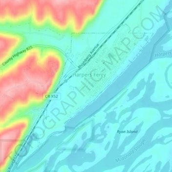
Name: Harpers Ferry topographic map, elevation, terrain.
Location: Harpers Ferry, Allamakee County, Iowa, United States (43.18901 -91.16364 43.20858 -91.13867)
Average elevation: 702 ft
Minimum elevation: 597 ft
Maximum elevation: 1,020 ft
Other topographic maps
Click on a map to view its topography, its elevation and its terrain.
New Albin
United States > Iowa > Allamakee County
New Albin, Allamakee County, Iowa, United States
Average elevation: 686 ft
Waukon
United States > Iowa > Allamakee County
Waukon, Allamakee County, Iowa, 52172, United States
Average elevation: 1,224 ft
Lansing
United States > Iowa > Allamakee County
Lansing, Allamakee County, Iowa, United States
Average elevation: 748 ft
Dorchester
United States > Iowa > Allamakee County
Dorchester, Allamakee County, Iowa, 52140, United States
Average elevation: 984 ft
Postville
United States > Iowa > Allamakee County
Postville, Allamakee County, Iowa, United States
Average elevation: 1,165 ft
Elon
United States > Iowa > Allamakee County
Elon, Allamakee County, Iowa, United States
Average elevation: 1,099 ft
Waterville
United States > Iowa > Allamakee County
Waterville, Allamakee County, Iowa, United States
Average elevation: 955 ft