
Winder topographic map
Interactive map
Click on the map to display elevation.
About this map
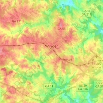
Name: Winder topographic map, elevation, terrain.
Location: Winder, Barrow County, Georgia, United States (33.93640 -83.76620 34.03697 -83.68046)
Average elevation: 899 ft
Minimum elevation: 725 ft
Maximum elevation: 1,056 ft
Other topographic maps
Click on a map to view its topography, its elevation and its terrain.
Auburn
United States > Georgia > Barrow County
Auburn, Barrow County, Georgia, 30011, United States
Average elevation: 984 ft
Statham
United States > Georgia > Barrow County
Statham, Barrow County, Georgia, United States
Average elevation: 856 ft
Carl
United States > Georgia > Barrow County
Carl, Barrow County, Georgia, United States
Average elevation: 1,040 ft
Russell
United States > Georgia > Barrow County
Russell, Barrow County, Georgia, 30680, United States
Average elevation: 915 ft
Bethlehem
United States > Georgia > Barrow County
Bethlehem, Barrow County, Georgia, United States
Average elevation: 846 ft