
Fairmount topographic map
Interactive map
Click on the map to display elevation.
About this map
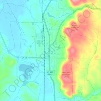
Name: Fairmount topographic map, elevation, terrain.
Location: Fairmount, Gordon County, Georgia, United States (34.41774 -84.71585 34.45686 -84.68914)
Average elevation: 817 ft
Minimum elevation: 679 ft
Maximum elevation: 1,115 ft
Other topographic maps
Click on a map to view its topography, its elevation and its terrain.
Plainville
United States > Georgia > Gordon County
Plainville, Gordon County, Georgia, United States
Average elevation: 699 ft
Sugar Valley
United States > Georgia > Gordon County
Sugar Valley, Gordon County, Georgia, 30746, United States
Average elevation: 682 ft
Calhoun
United States > Georgia > Gordon County
Calhoun, Gordon County, Georgia, 30701, United States
Average elevation: 689 ft
City of Plainville
United States > Georgia > Gordon County
City of Plainville, Gordon County, Georgia, United States
Average elevation: 699 ft
Ranger
United States > Georgia > Gordon County
Ranger, Gordon County, Georgia, United States
Average elevation: 827 ft
Calhoun
United States > Georgia > Gordon County > Calhoun > Calhoun
Calhoun, Gordon County, Georgia, 30701, United States
Average elevation: 676 ft
Resaca
United States > Georgia > Gordon County
Resaca, Gordon County, Georgia, United States
Average elevation: 653 ft