
Taiyuan topographic map
Interactive map
Click on the map to display elevation.
About this map
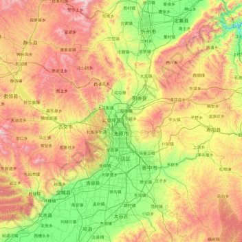
Name: Taiyuan topographic map, elevation, terrain.
Location: Taiyuan, Shanxi, China (37.44142 111.50892 38.42085 113.14779)
Average elevation: 3,921 ft
Minimum elevation: 1,804 ft
Maximum elevation: 7,795 ft
Taiyuan experiences a cold semi-arid climate (Köppen climate classification BSk). Taiyuan has a temperate monsoon climate.Spring is dry, with occasional dust storms, followed by early summer heat waves. Summer tends to be warm to hot with most of the year's rainfall concentrated in July and August. Winter is long and cold, but dry and sunny. Because of the aridity, there tends to be considerable diurnal variation in temperature, except during the summer. The weather is much cooler than comparable-latitude cities, such as Shijiazhuang, due to the moderately high altitude. The monthly 24-hour average temperature range from −5.0 °C (23.0 °F) in January to 24.0 °C (75.2 °F) in July, while the annual mean is 10.42 °C (50.8 °F). With monthly percent possible sunshine ranging from 51 percent in July to 61 percent in May, there are 2,502 hours of sunshine annually.
Other topographic maps
Click on a map to view its topography, its elevation and its terrain.
Pingyao County
China > Shanxi > Jinzhong City
Pingyao County, Jinzhong City, Shanxi, 031100, China
Average elevation: 3,701 ft
Hejin
China > Shanxi > Hejin City > Chengqu Subdistrict
Hejin, Chengqu Subdistrict, Hejin City, Yuncheng City, Shanxi, 043300, China
Average elevation: 1,736 ft
Linyi
China > Shanxi > Linyi County
Linyi, Linyi County, Yuncheng City, Shanxi, China
Average elevation: 1,493 ft
Shiba
China > Shanxi > Ningwu County > Shiba
Shiba, Ningwu County, Xinzhou City, Shanxi, China
Average elevation: 5,246 ft
Xiangning County
Xiangning County, Linfen City, Shanxi, China
Average elevation: 3,205 ft
Pingcheng District
China > Shanxi > Pingcheng District
Datong, Pingcheng District, Datong City, Shanxi, 037004, China
Average elevation: 3,770 ft
Gulou Subdistrict
China > Shanxi > Gulou Subdistrict
Gulou Subdistrict, Huozhou City, Linfen Shi, Shanxi, China
Average elevation: 1,837 ft
Yuncheng
China > Shanxi > Dongcheng Subdistrict
Yuncheng, Dongcheng Subdistrict, Yanhu District, Yuncheng City, Shanxi, 044031, China
Average elevation: 1,568 ft