
Golden topographic map
Interactive map
Click on the map to display elevation.
About this map
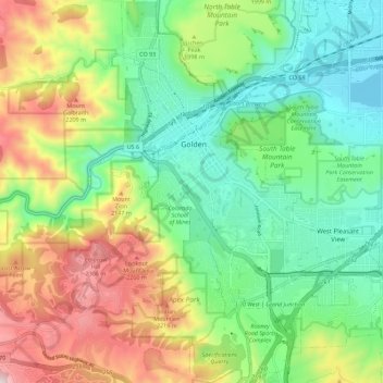
Name: Golden topographic map, elevation, terrain.
Location: Golden, Jefferson County, Colorado, United States (39.70061 -105.24196 39.78711 -105.16186)
Average elevation: 6,352 ft
Minimum elevation: 5,489 ft
Maximum elevation: 7,923 ft
Other topographic maps
Click on a map to view its topography, its elevation and its terrain.
Golden
United States > Colorado > Jefferson County > Golden > Golden
Golden, Jefferson County, Colorado, 80401, United States
Average elevation: 6,640 ft