
Wałbrzych topographic map
Interactive map
Click on the map to display elevation.
About this map
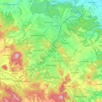
Name: Wałbrzych topographic map, elevation, terrain.
Average elevation: 1,568 ft
Minimum elevation: 902 ft
Maximum elevation: 2,785 ft
Wałbrzych is located in the of the Central Sudeten Mountains, near the border with the Czech Republic and Germany. The city is located by the Pełcznica River at 450-500 m above sea level in a picturesque structural basin of Wałbrzych above which there are wooded ranges of the Wałbrzych Mountains. The highest elevation in the city is Mount Borowa, also known as the Black Mountain, 853 m (2798ft) above sea level, with an observation tower since 2007, which is the highest peak of the Wałbrzych mountains.