
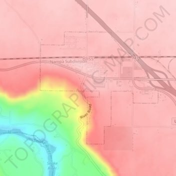
Bliss topographic map
Interactive map
Click on the map to display elevation.
About this map
Name: Bliss topographic map, elevation, terrain.
Location: Bliss, Gooding County, Idaho, United States (42.91362 -114.95932 42.93088 -114.93457)
Average elevation: 3,156 ft
Minimum elevation: 2,661 ft
Maximum elevation: 3,304 ft
Other topographic maps
Click on a map to view its topography, its elevation and its terrain.
Hagerman
United States > Idaho > Gooding County
Hagerman, Gooding County, Idaho, 83332, United States
Average elevation: 2,953 ft
Malad Gorge State Park
United States > Idaho > Gooding County
Malad Gorge State Park, Gooding County, Idaho, 83332, United States
Average elevation: 3,143 ft
Ritter Island
United States > Idaho > Gooding County
Ritter Island, Gooding County, Idaho, United States
Average elevation: 3,094 ft
Wendell
United States > Idaho > Gooding County > Wendell
Wendell, Gooding County, Idaho, 83355, United States
Average elevation: 3,425 ft