
Thurso topographic map
Interactive map
Click on the map to display elevation.
About this map
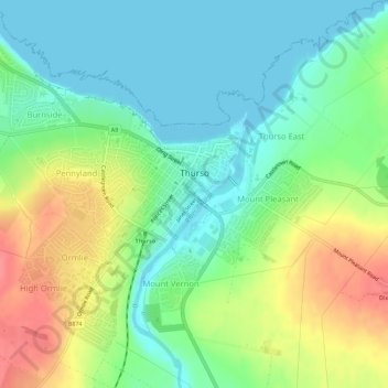
Name: Thurso topographic map, elevation, terrain.
Location: Thurso, Caithness, Scotland, United Kingdom (58.58098 -3.55606 58.60531 -3.50003)
Average elevation: 82 ft
Minimum elevation: 0 ft
Maximum elevation: 223 ft
Other topographic maps
Click on a map to view its topography, its elevation and its terrain.
Lybster
United Kingdom > Scotland > Caithness
Lybster, Caithness, Scotland, KW3 6AE, United Kingdom
Average elevation: 174 ft
Newport
United Kingdom > Scotland > Caithness > Newport
Newport, Caithness, Scotland, KW7 6HA, United Kingdom
Average elevation: 253 ft
John o' Groats
United Kingdom > Scotland > Caithness > John o' Groats
John o' Groats, Caithness, Scotland, KW1 4YR, United Kingdom
Average elevation: 52 ft
Wick
United Kingdom > Scotland > Caithness
Wick, Caithness, Scotland, KW1 4NB, United Kingdom
Average elevation: 66 ft