
Pleasantville topographic map
Interactive map
Click on the map to display elevation.
About this map
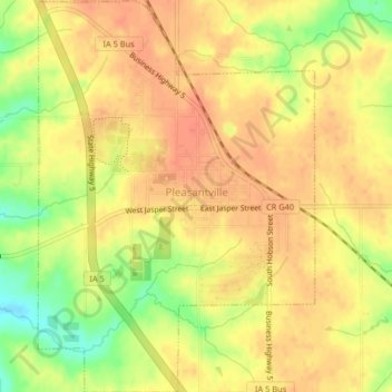
Name: Pleasantville topographic map, elevation, terrain.
Location: Pleasantville, Marion County, Iowa, 50225, United States (41.37112 -93.28603 41.40175 -93.25716)
Average elevation: 899 ft
Minimum elevation: 797 ft
Maximum elevation: 942 ft
Other topographic maps
Click on a map to view its topography, its elevation and its terrain.
Pella
United States > Iowa > Marion County
Pella, Marion County, Iowa, United States
Average elevation: 833 ft
Pella
United States > Iowa > Marion County > Pella
Pella, Marion County, Iowa, 50219, United States
Average elevation: 830 ft
Pleasantville
United States > Iowa > Marion County > Pleasantville
Pleasantville, Marion County, Iowa, 50225, United States
Average elevation: 889 ft
Knoxville
United States > Iowa > Marion County
Knoxville, Marion County, Iowa, United States
Average elevation: 869 ft