
West Liberty topographic map
Interactive map
Click on the map to display elevation.
About this map
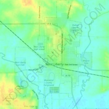
Name: West Liberty topographic map, elevation, terrain.
Location: West Liberty, Muscatine County, Iowa, 52776, United States (41.55598 -91.28036 41.58997 -91.24814)
Average elevation: 676 ft
Minimum elevation: 640 ft
Maximum elevation: 738 ft
Other topographic maps
Click on a map to view its topography, its elevation and its terrain.
New Era
United States > Iowa > Muscatine County
New Era, Muscatine County, Iowa, United States
Average elevation: 682 ft
Fruitland
United States > Iowa > Muscatine County
Fruitland, Muscatine County, Iowa, 52749, United States
Average elevation: 548 ft
Nichols
United States > Iowa > Muscatine County
Nichols, Muscatine County, Iowa, United States
Average elevation: 630 ft