
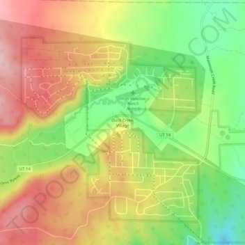
Duck Creek Village topographic map
Interactive map
Click on the map to display elevation.
About this map
Name: Duck Creek Village topographic map, elevation, terrain.
Average elevation: 8,556 ft
Minimum elevation: 8,179 ft
Maximum elevation: 8,914 ft
Other topographic maps
Click on a map to view its topography, its elevation and its terrain.
Long Valley Junction
United States > Utah > Kane County
Long Valley Junction, Kane County, Utah, 84710, United States
Average elevation: 7,530 ft
Navajo Lake
United States > Utah > Kane County > Navajo Lake Lodge
Navajo Lake, Navajo Lake Lodge, Kane County, Utah, United States
Average elevation: 9,354 ft
Coyote Gulch
United States > Utah > Kane County
Coyote Gulch, Kane County, Utah, United States
Average elevation: 4,465 ft
Lone Rock Beach
United States > Utah > Kane County
Lone Rock Beach, Kane County, Utah, United States
Average elevation: 3,720 ft
Spooky Gulch
United States > Utah > Kane County
Spooky Gulch, Kane County, Utah, United States
Average elevation: 4,829 ft
Cottonwood Point
United States > Utah > Kane County
Cottonwood Point, Kane County, Utah, United States
Average elevation: 5,384 ft