
Washington Mountain topographic map
Interactive map
Click on the map to display elevation.
About this map
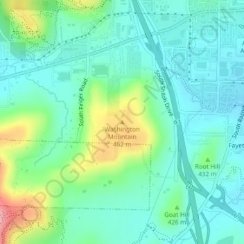
Name: Washington Mountain topographic map, elevation, terrain.
Average elevation: 1,342 ft
Minimum elevation: 1,227 ft
Maximum elevation: 1,663 ft
Other topographic maps
Click on a map to view its topography, its elevation and its terrain.
South Mountain
United States > Arkansas > Washington County > Fayetteville
South Mountain, Fayetteville, Washington County, Arkansas, 72701, United States
Average elevation: 1,329 ft
Fayetteville
United States > Arkansas > Washington County > Fayetteville
Fayetteville, Washington County, Arkansas, 72701, United States
Average elevation: 1,325 ft