
Passo dello Stelvio topographic map
Interactive map
Click on the map to display elevation.
About this map
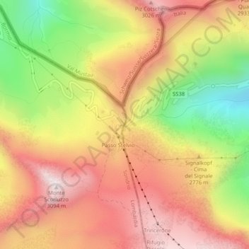
Name: Passo dello Stelvio topographic map, elevation, terrain.
Average elevation: 8,937 ft
Minimum elevation: 7,418 ft
Maximum elevation: 10,089 ft
The Stelvio Pass (Italian: Passo dello Stelvio [passo ˈdello ˈstɛlvjo], Giogo dello Stelvio [dʒɔgo ˈdello ˈstɛlvjo]; German: Stilfser Joch; [ˈʃtɪlfsɐ jɔx]) is a mountain pass in northern Italy bordering Switzerland at an elevation of 2,757 m (9,045 ft) above sea level. It is the highest paved mountain pass in the Eastern Alps, and the second highest in the Alps, 7 m (23 ft) below France's Col de l'Iseran (2,764 m (9,068 ft)).
Other topographic maps
Click on a map to view its topography, its elevation and its terrain.
Neuwies - Pratonuovo
Italy > Trentino-Alto Adige/Südtirol > South Tyrol > Stilfs - Stelvio > Trafoi
Neuwies - Pratonuovo, Trafoi, Stilfs - Stelvio, Vinschgau - Val Venosta, South Tyrol, Trentino-Alto Adige/Südtirol, 39029, Italy
Average elevation: 6,850 ft
Ortler - Ortles
Italy > Trentino-Alto Adige/Südtirol > South Tyrol > Stilfs - Stelvio
Ortler - Ortles, Stilfs - Stelvio, Vinschgau - Val Venosta, South Tyrol, Trentino-Alto Adige/Südtirol, Italy
Average elevation: 10,423 ft