
El Dorado topographic map
Interactive map
Click on the map to display elevation.
About this map
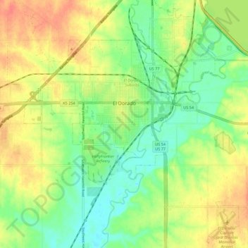
Name: El Dorado topographic map, elevation, terrain.
Location: El Dorado, Butler County, Kansas, 67042, United States (37.76663 -96.90675 37.85314 -96.81165)
Average elevation: 1,329 ft
Minimum elevation: 1,253 ft
Maximum elevation: 1,417 ft
Other topographic maps
Click on a map to view its topography, its elevation and its terrain.
Augusta
United States > Kansas > Butler County
Augusta, Butler County, Kansas, 67010, United States
Average elevation: 1,270 ft
Andover
United States > Kansas > Butler County
Andover, Butler County, Kansas, United States
Average elevation: 1,332 ft
Towanda
United States > Kansas > Butler County > Towanda
Towanda, Butler County, Kansas, United States
Average elevation: 1,289 ft
Whitewater
United States > Kansas > Butler County
Whitewater, Butler County, Kansas, United States
Average elevation: 1,375 ft
Augusta Lake
United States > Kansas > Butler County > Augusta
Augusta Lake, Augusta, Butler County, Kansas, United States
Average elevation: 1,273 ft
Douglass
United States > Kansas > Butler County
Douglass, Butler County, Kansas, United States
Average elevation: 1,207 ft