
Melba topographic map
Interactive map
Click on the map to display elevation.
About this map
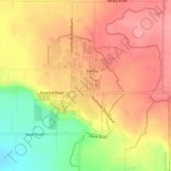
Name: Melba topographic map, elevation, terrain.
Location: Melba, Canyon County, Idaho, United States (43.36544 -116.54158 43.38086 -116.52360)
Average elevation: 2,618 ft
Minimum elevation: 2,405 ft
Maximum elevation: 2,746 ft
Melba is located at 43°22′25″N 116°31′45″W / 43.37361°N 116.52917°W / 43.37361; -116.52917 (43.373487, -116.529194). at an elevation of 2,667 feet (813 m) above sea level. It is 12 miles (19 km) south of Nampa, and three miles (5 km) northeast of the Snake River.
Other topographic maps
Click on a map to view its topography, its elevation and its terrain.
Nampa
United States > Idaho > Canyon County
Nampa, Canyon County, Idaho, United States
Average elevation: 2,507 ft
Caldwell
United States > Idaho > Canyon County
Caldwell, Canyon County, Idaho, United States
Average elevation: 2,434 ft
Middleton
United States > Idaho > Canyon County
Middleton, Canyon County, Idaho, 83644, United States
Average elevation: 2,431 ft
Nampa
United States > Idaho > Canyon County > Nampa
Nampa, Canyon County, Idaho, 83686, United States
Average elevation: 2,569 ft
Parma
United States > Idaho > Canyon County
Parma, Canyon County, Idaho, 83660, United States
Average elevation: 2,251 ft
Notus
United States > Idaho > Canyon County
Notus, Canyon County, Idaho, 83656, United States
Average elevation: 2,323 ft