
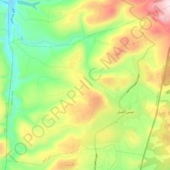
Meiss Ej-Jabal topographic map
Interactive map
Click on the map to display elevation.
About this map
Name: Meiss Ej-Jabal topographic map, elevation, terrain.
Average elevation: 2,067 ft
Minimum elevation: 1,421 ft
Maximum elevation: 2,805 ft
Other topographic maps
Click on a map to view its topography, its elevation and its terrain.
Klayaa
Lebanon > Nabatieh Governorate
Klayaa, Marjayoun District, Nabatieh Governorate, Lebanon
Average elevation: 1,706 ft
Kfour
Lebanon > Nabatieh Governorate
Kfour, Nabatieh District, Nabatieh Governorate, 1700, Lebanon
Average elevation: 1,325 ft
Nabatieh
Lebanon > Nabatieh Governorate
Nabatieh, Nabatieh District, Nabatieh Governorate, 1700, Lebanon
Average elevation: 1,539 ft
Marjayoun District
Lebanon > Nabatieh Governorate
Marjayoun District, Nabatieh Governorate, 1701, Lebanon
Average elevation: 1,427 ft
Chaqra
Lebanon > Nabatieh Governorate
Chaqra, Bint Jbeil District, Nabatieh Governorate, Lebanon
Average elevation: 2,087 ft