
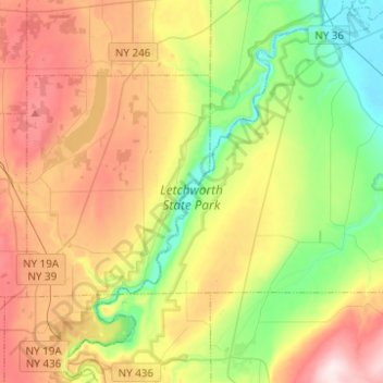
Letchworth State Park topographic map
Interactive map
Click on the map to display elevation.
About this map
Name: Letchworth State Park topographic map, elevation, terrain.
Average elevation: 1,171 ft
Minimum elevation: 551 ft
Maximum elevation: 2,018 ft
Other topographic maps
Click on a map to view its topography, its elevation and its terrain.
Walkers Corners
United States > New York > Livingston County
Walkers Corners, Town of York, Livingston County, New York, 14533, United States
Average elevation: 925 ft
Village of Avon
United States > New York > Livingston County > Town of Avon
Village of Avon, Town of Avon, Livingston County, New York, United States
Average elevation: 630 ft
Groveland Station
United States > New York > Livingston County
Groveland Station, Town of Groveland, Livingston County, New York, United States
Average elevation: 659 ft
Town of Groveland
United States > New York > Livingston County
Town of Groveland, Livingston County, New York, United States
Average elevation: 912 ft
Village of Lima
United States > New York > Livingston County
Village of Lima, Town of Lima, Livingston County, New York, United States
Average elevation: 830 ft
Hemlock
United States > New York > Livingston County
Hemlock, Town of Livonia, Livingston County, New York, United States
Average elevation: 1,001 ft
Town of Mount Morris
United States > New York > Livingston County
Town of Mount Morris, Livingston County, New York, 14510, United States
Average elevation: 876 ft
Town of York
United States > New York > Livingston County
Town of York, Livingston County, New York, United States
Average elevation: 784 ft
Hunt
United States > New York > Livingston County
Hunt, Town of Portage, Livingston County, New York, United States
Average elevation: 1,417 ft
Village of Geneseo
United States > New York > Livingston County > Town of Geneseo
Village of Geneseo, Town of Geneseo, Livingston County, New York, United States
Average elevation: 715 ft
Village of Dansville
United States > New York > Livingston County
Village of Dansville, Town of North Dansville, Livingston County, New York, 14437, United States
Average elevation: 951 ft
Pine Tavern
United States > New York > Livingston County
Pine Tavern, Town of Leicester, Livingston County, New York, 14481, United States
Average elevation: 928 ft
Sonyea
United States > New York > Livingston County
Sonyea, Town of Groveland, Livingston County, New York, 14556, United States
Average elevation: 650 ft
Town of Portage
United States > New York > Livingston County
Town of Portage, Livingston County, New York, 14846, United States
Average elevation: 1,273 ft
Dansville
United States > New York > Livingston County > Dansville
Dansville, Town of North Dansville, Livingston County, New York, 14437, United States
Average elevation: 909 ft
Idaho
United States > New York > Livingston County > Town of Lima > Idaho
Idaho, Town of Lima, Livingston County, New York, 14585, United States
Average elevation: 860 ft
Town of Geneseo
United States > New York > Livingston County
Town of Geneseo, Livingston County, New York, 14454, United States
Average elevation: 755 ft
Conesus
United States > New York > Livingston County
Conesus, Livingston County, New York, 14435, United States
Average elevation: 1,273 ft