
Lymm topographic map
Interactive map
Click on the map to display elevation.
About this map
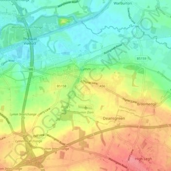
Name: Lymm topographic map, elevation, terrain.
Location: Lymm, Warrington, England, United Kingdom (53.35549 -2.51642 53.39622 -2.42538)
Average elevation: 125 ft
Minimum elevation: 20 ft
Maximum elevation: 269 ft
Other topographic maps
Click on a map to view its topography, its elevation and its terrain.
Croft
United Kingdom > England > Warrington > Culcheth
Croft, Culcheth, Warrington, England, United Kingdom
Average elevation: 85 ft
Warrington
United Kingdom > England > Warrington
Warrington, England, WA1 1TS, United Kingdom
Average elevation: 66 ft