
Ubud topographic map
Interactive map
Click on the map to display elevation.
About this map
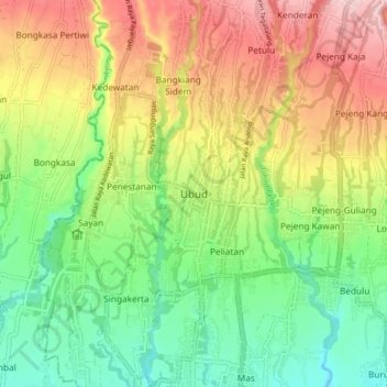
Name: Ubud topographic map, elevation, terrain.
Location: Ubud, Gianyar, Bali, 80571, Indonesia (-8.54690 115.22229 -8.46690 115.30229)
Average elevation: 705 ft
Minimum elevation: 361 ft
Maximum elevation: 1,171 ft
Other topographic maps
Click on a map to view its topography, its elevation and its terrain.
Mancingan
Indonesia > Bali > Gianyar > Tampak Siring
Mancingan, Tampak Siring, Gianyar, Bali, Lesser Sunda Islands, 80661, Indonesia
Average elevation: 1,683 ft