
Al Wajh topographic map
Interactive map
Click on the map to display elevation.
About this map
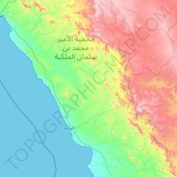
Name: Al Wajh topographic map, elevation, terrain.
Location: Al Wajh, Tabuk Province, Saudi Arabia (25.75675 36.04105 27.49729 37.69519)
Average elevation: 1,532 ft
Minimum elevation: -3 ft
Maximum elevation: 6,726 ft
Other topographic maps
Click on a map to view its topography, its elevation and its terrain.
Al Bad`
Al Bad`, Al Bad, Tabuk Province, Saudi Arabia
Average elevation: 843 ft
السرو
السرو, Tabuk Governorate, Tabuk Province, Saudi Arabia
Average elevation: 3,839 ft
Al Khuraybah
Al Khuraybah, Governorate of Duba, Tabuk Province, 49623, Saudi Arabia
Average elevation: 39 ft
Neom
Neom, Governorate of Duba, Tabuk Province, Saudi Arabia
Average elevation: 171 ft
Gulf of Aqaba
Gulf of Aqaba, Tabuk Province, Saudi Arabia
Average elevation: 2,372 ft
Jabal al Lawz
Jabal al Lawz, Tabuk Governorate, Tabuk Province, Saudi Arabia
Average elevation: 6,883 ft
Tabuk
Tabuk, Tabuk Governorate, Tabuk Province, 71411, Saudi Arabia
Average elevation: 2,543 ft