
King Salmon topographic map
Interactive map
Click on the map to display elevation.
About this map
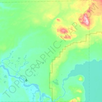
Name: King Salmon topographic map, elevation, terrain.
Location: King Salmon, Bristol Bay, Alaska, United States (58.61540 -156.78112 58.89495 -156.31722)
Average elevation: 177 ft
Minimum elevation: 3 ft
Maximum elevation: 1,050 ft
Other topographic maps
Click on a map to view its topography, its elevation and its terrain.
South Naknek
United States > Alaska > Bristol Bay
South Naknek, Bristol Bay, Alaska, 99670, United States
Average elevation: 92 ft