
Dorchester topographic map
Interactive map
Click on the map to display elevation.
About this map
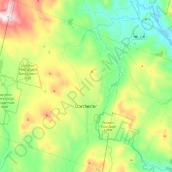
Name: Dorchester topographic map, elevation, terrain.
Location: Dorchester, Grafton County, New Hampshire, United States (43.70581 -72.05818 43.83795 -71.90782)
Average elevation: 1,440 ft
Minimum elevation: 502 ft
Maximum elevation: 3,212 ft
According to the United States Census Bureau, the town has a total area of 45.2 square miles (117.1 km2), of which 44.6 square miles (115.5 km2) are land and 0.62 square miles (1.6 km2) are water, comprising 1.34% of the town. It is drained by the north-flowing South Branch Baker River and the south-flowing Mascoma River and its tributary, the Indian River. Cummins Pond and Reservoir Pond are in the west. The northeastern half of town which drains to the South Branch of the Baker is part of the Merrimack River watershed, while the southwestern half is part of the Connecticut River watershed. The highest point in Dorchester is on its western boundary, where the elevation reaches 3,190 feet (970 m) above sea level, just east of the summit of Smarts Mountain.
Other topographic maps
Click on a map to view its topography, its elevation and its terrain.
East Hebron
United States > New Hampshire > Grafton County > Hebron
East Hebron, Hebron, Grafton County, New Hampshire, 03241, United States
Average elevation: 879 ft
Montcalm
United States > New Hampshire > Grafton County
Montcalm, Grafton County, New Hampshire, 03748, United States
Average elevation: 1,430 ft
Ashland
United States > New Hampshire > Grafton County
Ashland, Grafton County, New Hampshire, 03217, United States
Average elevation: 758 ft
Easton
United States > New Hampshire > Grafton County
Easton, Grafton County, New Hampshire, United States
Average elevation: 1,923 ft
Lyme Center
United States > New Hampshire > Grafton County > Lyme
Lyme Center, Lyme, Grafton County, New Hampshire, 03769, United States
Average elevation: 1,102 ft
Pike
United States > New Hampshire > Grafton County > Haverhill
Pike, Haverhill, Grafton County, New Hampshire, 03765, United States
Average elevation: 942 ft
Stinson Lake
United States > New Hampshire > Grafton County > Rumney > Stinson Lake
Stinson Lake, Rumney, Grafton County, New Hampshire, United States
Average elevation: 1,509 ft
West Lebanon
United States > New Hampshire > Grafton County > Lebanon
West Lebanon, Lebanon, Grafton County, New Hampshire, 03784, United States
Average elevation: 541 ft
Benton
United States > New Hampshire > Grafton County
Benton, Grafton County, New Hampshire, United States
Average elevation: 1,831 ft
Bridgewater
United States > New Hampshire > Grafton County
Bridgewater, Grafton County, New Hampshire, United States
Average elevation: 991 ft
Holderness
United States > New Hampshire > Grafton County
Holderness, Grafton County, New Hampshire, 03245, United States
Average elevation: 827 ft
Monroe
United States > New Hampshire > Grafton County
Monroe, Grafton County, New Hampshire, 03771, United States
Average elevation: 1,050 ft
North Woodstock
United States > New Hampshire > Grafton County > Woodstock
North Woodstock, Woodstock, Grafton County, New Hampshire, 03262, United States
Average elevation: 1,004 ft
Woodsville
United States > New Hampshire > Grafton County > Haverhill
Woodsville, Haverhill, Grafton County, New Hampshire, 05081, United States
Average elevation: 640 ft
Enfield Center
United States > New Hampshire > Grafton County > Enfield
Enfield Center, Enfield, Grafton County, New Hampshire, 03749, United States
Average elevation: 1,171 ft
Glencliff
United States > New Hampshire > Grafton County > Warren
Glencliff, Warren, Grafton County, New Hampshire, 03238, United States
Average elevation: 1,345 ft
Jewell Hill
United States > New Hampshire > Grafton County > Groton
Jewell Hill, Groton, Grafton County, New Hampshire, United States
Average elevation: 1,529 ft
Boutin Corner
United States > New Hampshire > Grafton County > Benton
Boutin Corner, Benton, Grafton County, New Hampshire, United States
Average elevation: 1,463 ft
Russel Pond
United States > New Hampshire > Grafton County > Woodstock
Russel Pond, Woodstock, Grafton County, New Hampshire, United States
Average elevation: 1,683 ft
Bristol
United States > New Hampshire > Grafton County
Bristol, Grafton County, New Hampshire, 03222, United States
Average elevation: 833 ft
Bethlehem
United States > New Hampshire > Grafton County
Bethlehem, Grafton County, New Hampshire, 03574, United States
Average elevation: 1,732 ft
Pine Knob
United States > New Hampshire > Grafton County > Bethlehem
Pine Knob, Bethlehem, Grafton County, New Hampshire, United States
Average elevation: 1,355 ft
Mount Pemigewasset
United States > New Hampshire > Grafton County > Lincoln
Mount Pemigewasset, Lincoln, Grafton County, New Hampshire, United States
Average elevation: 1,995 ft
Campton Lower Village
United States > New Hampshire > Grafton County > Campton
Campton Lower Village, Campton, Grafton County, New Hampshire, 03223, United States
Average elevation: 853 ft
Parker Hill
United States > New Hampshire > Grafton County > Lyman
Parker Hill, Lyman, Grafton County, New Hampshire, United States
Average elevation: 1,148 ft
Cheever
United States > New Hampshire > Grafton County > Dorchester
Cheever, Dorchester, Grafton County, New Hampshire, United States
Average elevation: 1,083 ft
Campton
United States > New Hampshire > Grafton County
Campton, Grafton County, New Hampshire, 03223, United States
Average elevation: 1,102 ft
Sugar Hill
United States > New Hampshire > Grafton County
Sugar Hill, Grafton County, New Hampshire, 03586, United States
Average elevation: 1,220 ft
Ashland Mill Dam
United States > New Hampshire > Grafton County > Ashland
Ashland Mill Dam, Ashland, Grafton County, New Hampshire, 03217, United States
Average elevation: 669 ft
Plymouth
United States > New Hampshire > Grafton County
Plymouth, Grafton County, New Hampshire, 03264, United States
Average elevation: 866 ft
Ellsworth
United States > New Hampshire > Grafton County
Ellsworth, Grafton County, New Hampshire, United States
Average elevation: 1,457 ft
Waterville Valley
United States > New Hampshire > Grafton County
Waterville Valley, Grafton County, New Hampshire, 03215, United States
Average elevation: 2,129 ft
Goose Pond
United States > New Hampshire > Grafton County > Canaan
Goose Pond, Canaan, Grafton County, New Hampshire, United States
Average elevation: 1,043 ft
Rumney
United States > New Hampshire > Grafton County
Rumney, Grafton County, New Hampshire, 03266, United States
Average elevation: 1,276 ft
Downing Mountain
United States > New Hampshire > Grafton County > Ellsworth
Downing Mountain, Ellsworth, Grafton County, New Hampshire, United States
Average elevation: 1,460 ft
Canaan
United States > New Hampshire > Grafton County
Canaan, Grafton County, New Hampshire, 03741, United States
Average elevation: 1,325 ft
Lyman
United States > New Hampshire > Grafton County
Lyman, Grafton County, New Hampshire, United States
Average elevation: 1,138 ft
Wentworth
United States > New Hampshire > Grafton County
Wentworth, Grafton County, New Hampshire, 03282, United States
Average elevation: 1,385 ft
Hebron
United States > New Hampshire > Grafton County
Hebron, Grafton County, New Hampshire, 03241, United States
Average elevation: 1,073 ft
Fairview
United States > New Hampshire > Grafton County > Woodstock
Fairview, Woodstock, Grafton County, New Hampshire, 03262, United States
Average elevation: 1,198 ft
Bath
United States > New Hampshire > Grafton County
Bath, Grafton County, New Hampshire, 03740, United States
Average elevation: 948 ft
Mountain Lakes
United States > New Hampshire > Grafton County > Haverhill
Mountain Lakes, Haverhill, Grafton County, New Hampshire, 03740, United States
Average elevation: 922 ft
Littleton
United States > New Hampshire > Grafton County
Littleton, Grafton County, New Hampshire, 03561, United States
Average elevation: 1,181 ft
Lonesome Lake
United States > New Hampshire > Grafton County > Lincoln
Lonesome Lake, Lincoln, Grafton County, New Hampshire, United States
Average elevation: 2,657 ft
Grafton
United States > New Hampshire > Grafton County
Grafton, Grafton County, New Hampshire, 03240, United States
Average elevation: 1,342 ft
Campton
United States > New Hampshire > Grafton County > Campton > Campton
Campton, Grafton County, New Hampshire, 03223, United States
Average elevation: 837 ft
Haverhill
United States > New Hampshire > Grafton County
Haverhill, Grafton County, New Hampshire, United States
Average elevation: 876 ft
Woodstock
United States > New Hampshire > Grafton County > Woodstock > Woodstock
Woodstock, Grafton County, New Hampshire, 03262, United States
Average elevation: 1,093 ft
Orange
United States > New Hampshire > Grafton County
Orange, Grafton County, New Hampshire, United States
Average elevation: 1,499 ft
Meadow Brook
United States > New Hampshire > Grafton County
Meadow Brook, Livermore, Grafton County, New Hampshire, United States
Average elevation: 1,864 ft