
Heber topographic map
Interactive map
Click on the map to display elevation.
About this map
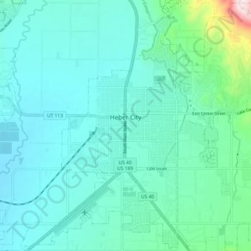
Name: Heber topographic map, elevation, terrain.
Location: Heber, Wasatch County, Utah, 84032, United States (40.47148 -111.44473 40.53675 -111.35712)
Average elevation: 5,699 ft
Minimum elevation: 5,453 ft
Maximum elevation: 7,119 ft
Heber City is located at 40°30′24″N 111°24′44″W / 40.506793°N 111.412292°W / 40.506793; -111.412292 (40.506793, -111.412292), at an elevation of 5595 feet. The region in which Heber City is located is known as the Wasatch Back.
Other topographic maps
Click on a map to view its topography, its elevation and its terrain.
Heber City
United States > Utah > Wasatch County > Heber > Heber City
Heber City, Heber, Wasatch County, Utah, 84032, United States
Average elevation: 5,771 ft
Soapstone Mountain
United States > Utah > Wasatch County
Soapstone Mountain, Wasatch County, Utah, United States
Average elevation: 8,924 ft
Timber Lakes
United States > Utah > Wasatch County
Timber Lakes, Wasatch County, Utah, United States
Average elevation: 8,179 ft
Charleston
United States > Utah > Wasatch County
Charleston, Wasatch County, Utah, United States
Average elevation: 5,528 ft
Midway
United States > Utah > Wasatch County
Midway, Wasatch County, Utah, 84049, United States
Average elevation: 5,745 ft
Strawberry Reservoir
United States > Utah > Wasatch County
Strawberry Reservoir, Wasatch County, Utah, United States
Average elevation: 7,848 ft
Silver Lake
United States > Utah > Wasatch County
Silver Lake, Wasatch County, Utah, United States
Average elevation: 9,491 ft
West Fork Duschene River
United States > Utah > Wasatch County
West Fork Duschene River, Wasatch County, Utah, United States
Average elevation: 9,573 ft
Deer Creek Reservoir
United States > Utah > Wasatch County > Charleston
Deer Creek Reservoir, Charleston, Wasatch County, Utah, United States
Average elevation: 5,853 ft
Jordanelle
United States > Utah > Wasatch County
Jordanelle, Wasatch County, Utah, United States
Average elevation: 6,447 ft
Wallsburg
United States > Utah > Wasatch County > Wallsburg
Wallsburg, Wasatch County, Utah, United States
Average elevation: 5,794 ft
Phosphate Hill
United States > Utah > Wasatch County
Phosphate Hill, Wasatch County, Utah, 84049, United States
Average elevation: 6,309 ft
Daniel
United States > Utah > Wasatch County
Daniel, Wasatch County, Utah, United States
Average elevation: 6,129 ft