
North Potomac topographic map
Interactive map
Click on the map to display elevation.
About this map
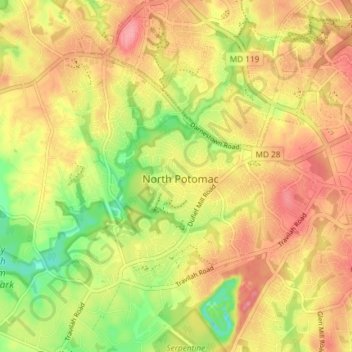
Name: North Potomac topographic map, elevation, terrain.
Location: North Potomac, Montgomery County, Maryland, United States (39.07841 -77.26774 39.11850 -77.19406)
Average elevation: 381 ft
Minimum elevation: 210 ft
Maximum elevation: 505 ft
Between the 1990 and 2000 census, North Potomac gained and lost land. The loss was caused when a portion of the North Potomac territory, plus Potomac territory, was used to create the Travilah census designated place. According to the United States Census Bureau, North Potomac has a total area of 6.6 square miles (17 km2), virtually all land. The Muddy Branch and its tributary Rich Branch are streams that run through North Potomac, and the Muddy Branch empties into the Potomac River. The United States Geological Survey lists two features in Montgomery County with North Potomac in all or part of their name. The North Potomac Census Designated Place is listed with an elevation of 390 feet (120 m), while the North Potomac Populated Place has an elevation of 256 feet (78 m).
Other topographic maps
Click on a map to view its topography, its elevation and its terrain.
Silver Spring
United States > Maryland > Montgomery County > Silver Spring
Silver Spring, Montgomery County, Maryland, United States
Average elevation: 282 ft
Gaithersburg
United States > Maryland > Montgomery County
Gaithersburg, Montgomery County, Maryland, United States
Average elevation: 449 ft
Laytonsville
United States > Maryland > Montgomery County
Laytonsville, Montgomery County, Maryland, United States
Average elevation: 564 ft
Damascus
United States > Maryland > Montgomery County
Damascus, Montgomery County, Maryland, 20872, United States
Average elevation: 669 ft
Clarksburg
United States > Maryland > Montgomery County
Clarksburg, Montgomery County, Maryland, United States
Average elevation: 545 ft
White Oak
United States > Maryland > Montgomery County
White Oak, Montgomery County, Maryland, 20904, United States
Average elevation: 315 ft
Montgomery Village
United States > Maryland > Montgomery County
Montgomery Village, Montgomery County, Maryland, 20886, United States
Average elevation: 456 ft
Kemp Mill
United States > Maryland > Montgomery County
Kemp Mill, Montgomery County, Maryland, 20901, United States
Average elevation: 341 ft
Flower Hill
United States > Maryland > Montgomery County > Redland
Flower Hill, Redland, Montgomery County, Maryland, 20879, United States
Average elevation: 482 ft
Fairland
United States > Maryland > Montgomery County
Fairland, Montgomery County, Maryland, United States
Average elevation: 364 ft
Quail Ridge
United States > Maryland > Montgomery County > Montgomery Village
Quail Ridge, Montgomery Village, Montgomery County, Maryland, 20876, United States
Average elevation: 436 ft
Cabin John
United States > Maryland > Montgomery County
Cabin John, Montgomery County, Maryland, 20818, United States
Average elevation: 157 ft
Chevy Chase Village
United States > Maryland > Montgomery County
Chevy Chase Village, Montgomery County, Maryland, United States
Average elevation: 325 ft
Layhill
United States > Maryland > Montgomery County
Layhill, Montgomery County, Maryland, 20906, United States
Average elevation: 381 ft
Glenmont
United States > Maryland > Montgomery County
Glenmont, Montgomery County, Maryland, 20902, United States
Average elevation: 358 ft
Redland
United States > Maryland > Montgomery County
Redland, Montgomery County, Maryland, 20855, United States
Average elevation: 456 ft
Cloverly
United States > Maryland > Montgomery County
Cloverly, Montgomery County, Maryland, 20905, United States
Average elevation: 456 ft
Dickerson
United States > Maryland > Montgomery County
Dickerson, Montgomery County, Maryland, 20842, United States
Average elevation: 364 ft
Glen Echo
United States > Maryland > Montgomery County
Glen Echo, Montgomery County, Maryland, 20812, United States
Average elevation: 180 ft
Colesville
United States > Maryland > Montgomery County
Colesville, Montgomery County, Maryland, 20904, United States
Average elevation: 384 ft
Aspen Hill
United States > Maryland > Montgomery County
Aspen Hill, Montgomery County, Maryland, 20906, United States
Average elevation: 374 ft
Colesville
United States > Maryland > Montgomery County > Colesville
Colesville, Montgomery County, Maryland, 20904, United States
Average elevation: 371 ft
Woodstock Equestrian Park
United States > Maryland > Montgomery County
Woodstock Equestrian Park, 20207, Montgomery County, Maryland, 20842, United States
Average elevation: 407 ft
Germantown
United States > Maryland > Montgomery County
Germantown, Montgomery County, Maryland, 20874, United States
Average elevation: 446 ft
Patuxent River State Park
United States > Maryland > Montgomery County
Patuxent River State Park, Montgomery County, Maryland, United States
Average elevation: 554 ft
Darnestown
United States > Maryland > Montgomery County
Darnestown, Montgomery County, Maryland, United States
Average elevation: 318 ft
Deerfield
United States > Maryland > Montgomery County > Potomac
Deerfield, Potomac, Montgomery County, Maryland, 20817, United States
Average elevation: 276 ft
Kemp Mill Estates
United States > Maryland > Montgomery County > Kemp Mill
Kemp Mill Estates, Kemp Mill, Montgomery County, Maryland, 20902, United States
Average elevation: 351 ft
South Kensington
United States > Maryland > Montgomery County
South Kensington, Montgomery County, Maryland, United States
Average elevation: 302 ft
Farmlands
United States > Maryland > Montgomery County > Travilah
Farmlands, Travilah, Montgomery County, Maryland, United States
Average elevation: 305 ft
Damascus
United States > Maryland > Montgomery County > Damascus
Damascus, Montgomery County, Maryland, 20872, United States
Average elevation: 640 ft
Germantown
United States > Maryland > Montgomery County > Germantown
Germantown, Montgomery County, Maryland, United States
Average elevation: 427 ft
Garrett Park
United States > Maryland > Montgomery County
Garrett Park, Montgomery County, Maryland, 20896, United States
Average elevation: 295 ft
Chevy Chase View
United States > Maryland > Montgomery County
Chevy Chase View, Montgomery County, Maryland, United States
Average elevation: 269 ft
Hunting Hill
United States > Maryland > Montgomery County > Rockville
Hunting Hill, Rockville, Montgomery County, Maryland, 20850, United States
Average elevation: 417 ft
Olney
United States > Maryland > Montgomery County
Olney, Montgomery County, Maryland, United States
Average elevation: 446 ft
Norbeck
United States > Maryland > Montgomery County > Olney
Norbeck, Olney, Montgomery County, Maryland, 20853, United States
Average elevation: 440 ft
Chevy Chase
United States > Maryland > Montgomery County
Chevy Chase, Montgomery County, Maryland, 20815, United States
Average elevation: 325 ft
Lake Needwood
United States > Maryland > Montgomery County > Redland > Avery
Lake Needwood, Avery, Redland, Montgomery County, Maryland, United States
Average elevation: 400 ft
Seneca
United States > Maryland > Montgomery County > Darnestown
Seneca, Darnestown, Montgomery County, Maryland, United States
Average elevation: 269 ft
Bethesda
United States > Maryland > Montgomery County
Bethesda, Montgomery County, Maryland, United States
Average elevation: 266 ft
White Oak
United States > Maryland > Montgomery County > White Oak
White Oak, Montgomery County, Maryland, 20993, United States
Average elevation: 331 ft
Rockville
United States > Maryland > Montgomery County
Rockville, Montgomery County, Maryland, United States
Average elevation: 400 ft
Great Falls
United States > Maryland > Montgomery County > Potomac
Great Falls, Potomac, Montgomery County, Maryland, United States
Average elevation: 240 ft
Orchard Place
United States > Maryland > Montgomery County > Gaithersburg
Orchard Place, Gaithersburg, Montgomery County, Maryland, 20899, United States
Average elevation: 420 ft
Washington Grove
United States > Maryland > Montgomery County
Washington Grove, Montgomery County, Maryland, 20880, United States
Average elevation: 492 ft
Sandy Spring
United States > Maryland > Montgomery County
Sandy Spring, Montgomery County, Maryland, 20860, United States
Average elevation: 449 ft
Campbell Corner
United States > Maryland > Montgomery County > Potomac
Campbell Corner, Potomac, Montgomery County, Maryland, 20818, United States
Average elevation: 269 ft
Derwood
United States > Maryland > Montgomery County
Derwood, Montgomery County, Maryland, 20855, United States
Average elevation: 436 ft
Montgomery Village
United States > Maryland > Montgomery County > Montgomery Village
Montgomery Village, Montgomery County, Maryland, 20886, United States
Average elevation: 433 ft