
Clarendon topographic map
Interactive map
Click on the map to display elevation.
About this map
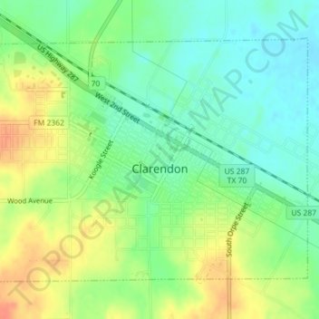
Name: Clarendon topographic map, elevation, terrain.
Location: Clarendon, Donley County, Texas, 79226, United States (34.92559 -100.90961 34.94785 -100.87412)
Average elevation: 2,762 ft
Minimum elevation: 2,700 ft
Maximum elevation: 2,844 ft
Other topographic maps
Click on a map to view its topography, its elevation and its terrain.
Howardwick
United States > Texas > Donley County
Howardwick, Donley County, Texas, United States
Average elevation: 2,726 ft
Hedley
United States > Texas > Donley County
Hedley, Donley County, Texas, United States
Average elevation: 2,625 ft