
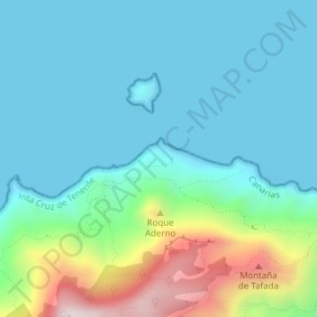
El Hoyo topographic map
Interactive map
Click on the map to display elevation.
About this map
Name: El Hoyo topographic map, elevation, terrain.
Location: El Hoyo, Santa Cruz de Tenerife, Canary Islands, Spain (28.58595 -16.15855 28.58859 -16.15824)
Average elevation: 502 ft
Minimum elevation: 0 ft
Maximum elevation: 2,369 ft
Other topographic maps
Click on a map to view its topography, its elevation and its terrain.
Playa de Antequera
Spain > Canary Islands > Santa Cruz de Tenerife
Playa de Antequera, Dangerous Trail, Lomo de la Cruz, Las Casillas, Anaga, Santa Cruz de Tenerife, Canary Islands, 38129, Spain
Average elevation: 358 ft
El Rincón
Spain > Canary Islands > Santa Cruz de Tenerife
El Rincón, Santa Cruz de Tenerife, Canary Islands, Spain
Average elevation: 1,122 ft
La Florida
Spain > Canary Islands > Santa Cruz de Tenerife
La Florida, Santa Cruz de Tenerife, Canary Islands, 38120, Spain
Average elevation: 285 ft
Macizo de Anaga
Spain > Canary Islands > Santa Cruz de Tenerife
Macizo de Anaga, Santa Cruz de Tenerife, Canary Islands, Spain
Average elevation: 659 ft