
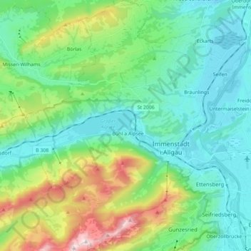
Immenstadt im Allgäu topographic map
Interactive map
Click on the map to display elevation.
About this map
Name: Immenstadt im Allgäu topographic map, elevation, terrain.
Average elevation: 3,012 ft
Minimum elevation: 2,287 ft
Maximum elevation: 5,679 ft
Other topographic maps
Click on a map to view its topography, its elevation and its terrain.
Bischlags
Germany > Bavaria > Landkreis Oberallgäu > Seebach
Bischlags, Seebach, Haldenwang, Landkreis Oberallgäu, Bavaria, 87490, Germany
Average elevation: 2,428 ft
Blaichach
Germany > Bavaria > Landkreis Oberallgäu
Blaichach, Landkreis Oberallgäu, Bavaria, 87544, Germany
Average elevation: 3,291 ft
Ellensberg
Germany > Bavaria > Landkreis Oberallgäu > Lauben
Ellensberg, Lauben, Landkreis Oberallgäu, Bavaria, Germany
Average elevation: 2,208 ft