
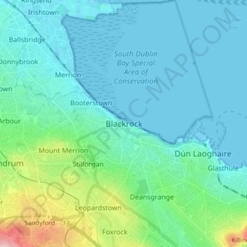
Blackrock topographic map
Interactive map
Click on the map to display elevation.
About this map
Name: Blackrock topographic map, elevation, terrain.
Average elevation: 98 ft
Minimum elevation: -7 ft
Maximum elevation: 610 ft
Other topographic maps
Click on a map to view its topography, its elevation and its terrain.
Ballybrack
Ireland > County Dublin > Killiney
Ballybrack, Killiney North DED 1986, Killiney, Dún Laoghaire-Rathdown, County Dublin, Leinster, Ireland
Average elevation: 105 ft
Carrickmines Little
Ireland > County Dublin > Ballyogan
Carrickmines Little, Glencullen Electoral Division, Ballyogan, Dún Laoghaire-Rathdown, County Dublin, Leinster, Ireland
Average elevation: 272 ft
Ballyogan
Ballyogan, Dún Laoghaire-Rathdown, County Dublin, Leinster, D18 X456, Ireland
Average elevation: 381 ft
Alder
Ireland > County Dublin > Goatstown
Alder, Mount Anville Park, Mountanville, Stillorgan-Deerpark DED 1986, Goatstown, Dún Laoghaire-Rathdown, County Dublin, Leinster, A94 RX70, Ireland
Average elevation: 187 ft
Cornelscourt
Cornelscourt, Dún Laoghaire-Rathdown, County Dublin, Leinster, D18 TD00, Ireland
Average elevation: 194 ft
Ballyhack
Ballyhack, Kilsallaghan ED, Fingal, County Dublin, Leinster, Ireland
Average elevation: 223 ft
Goatstown
Goatstown, Dún Laoghaire-Rathdown, County Dublin, Leinster, D14 WR83, Ireland
Average elevation: 187 ft
Charstown
Charstown, Garristown ED, Fingal, County Dublin, Leinster, Ireland
Average elevation: 325 ft
Mountmerrion or Callary
Ireland > County Dublin > Dundrum
Mountmerrion or Callary, Mount Merrion, Stillorgan-Deerpark ED, Dundrum, Dún Laoghaire-Rathdown, County Dublin, Leinster, Ireland
Average elevation: 144 ft
14
Ireland > County Dublin > Blackrock
14, The Stables, Mount Merrion, Mountmerrion or Callary, Stillorgan-Mount Merrion ED, Blackrock, Dún Laoghaire-Rathdown, County Dublin, Leinster, A94 EK75, Ireland
Average elevation: 157 ft
Clondalkin
Clondalkin, South Dublin, County Dublin, Leinster, D22 E9X5, Ireland
Average elevation: 226 ft
Dún Laoghaire
Dún Laoghaire, Dún Laoghaire-Rathdown, County Dublin, Leinster, A96 T860, Ireland
Average elevation: 69 ft
South Dublin
South Dublin, County Dublin, Leinster, Ireland
Average elevation: 600 ft