
Wan Chai District topographic map
Interactive map
Click on the map to display elevation.
About this map
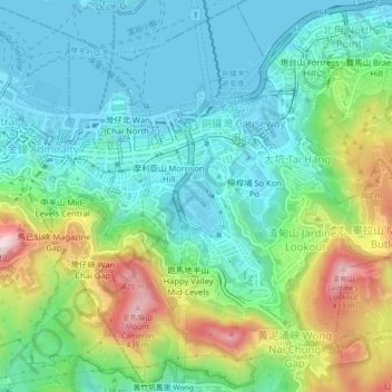
Name: Wan Chai District topographic map, elevation, terrain.
Location: Wan Chai District, Hong Kong Island, Hong Kong, China (22.25404 114.16316 22.29387 114.20717)
Average elevation: 400 ft
Minimum elevation: -10 ft
Maximum elevation: 1,394 ft
Other topographic maps
Click on a map to view its topography, its elevation and its terrain.
Southern District
Southern District, Hong Kong Island, Hong Kong, 852, China
Average elevation: 118 ft
Sham Shui Po District
Sham Shui Po District, Kowloon, Hong Kong, China
Average elevation: 190 ft