
Crowthorne topographic map
Interactive map
Click on the map to display elevation.
About this map
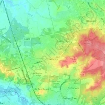
Name: Crowthorne topographic map, elevation, terrain.
Location: Crowthorne, Bracknell Forest, England, United Kingdom (51.35798 -0.81973 51.39086 -0.72733)
Average elevation: 269 ft
Minimum elevation: 161 ft
Maximum elevation: 443 ft
Other topographic maps
Click on a map to view its topography, its elevation and its terrain.
Winkfield
United Kingdom > England > Bracknell Forest
Winkfield, Bracknell Forest, England, United Kingdom
Average elevation: 240 ft
Bracknell
United Kingdom > England > Bracknell Forest
Bracknell, Bracknell Forest, England, United Kingdom
Average elevation: 266 ft
Sandhurst
United Kingdom > England > Bracknell Forest
Sandhurst, Bracknell Forest, South East England, England, United Kingdom
Average elevation: 276 ft
Binfield
United Kingdom > England > Bracknell Forest
Binfield, Bracknell Forest, England, United Kingdom
Average elevation: 190 ft