
Алатауский район topographic map
Interactive map
Click on the map to display elevation.
About this map
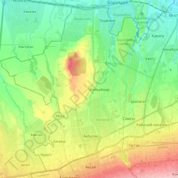
Name: Алатауский район topographic map, elevation, terrain.
Location: Алатауский район, Almaty, Kazakhstan (43.23223 76.73828 43.35470 76.92126)
Average elevation: 2,441 ft
Minimum elevation: 2,224 ft
Maximum elevation: 2,838 ft
Other topographic maps
Click on a map to view its topography, its elevation and its terrain.
Almaty
Almaty, Бостандыкский район, Almaty, 050013, Kazakhstan
Average elevation: 4,137 ft
Комсомолец
Комсомолец, На ледник Богдановича, Медеуский район, Almaty, Kazakhstan
Average elevation: 11,946 ft