
Ghandruk topographic map
Interactive map
Click on the map to display elevation.
About this map
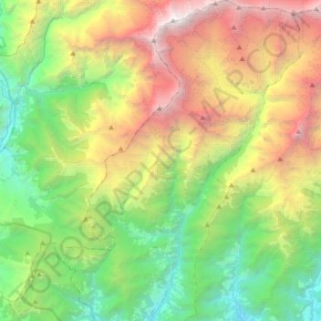
Name: Ghandruk topographic map, elevation, terrain.
Location: Ghandruk, Annapurna, Kaski, Gandaki Pradesh, Nepal (28.33059 83.73171 28.61295 83.99117)
Average elevation: 11,572 ft
Minimum elevation: 3,602 ft
Maximum elevation: 26,309 ft
Other topographic maps
Click on a map to view its topography, its elevation and its terrain.
Dhampus Phedi
Dhampus Phedi, Dhampus, Machhapuchchhre, Kaski, Gandaki Pradesh, Nepal
Average elevation: 4,839 ft
Annapurna I
Annapurna I, Ghandruk, Annapurna, Kaski, Gandaki Pradesh, Nepal
Average elevation: 23,383 ft