
Klingenthal topographic map
Interactive map
Click on the map to display elevation.
About this map
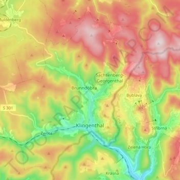
Name: Klingenthal topographic map, elevation, terrain.
Location: Klingenthal, Vogtlandkreis, Saksen, Duitsland (50.33373 12.36468 50.42047 12.51679)
Average elevation: 2,408 ft
Minimum elevation: 1,693 ft
Maximum elevation: 3,143 ft
Other topographic maps
Click on a map to view its topography, its elevation and its terrain.
Reuth
Duitsland > Saksen > Vogtlandkreis > Schönlind
Reuth, Schönlind, Weischlitz, Vogtlandkreis, Saksen, 08538, Duitsland
Average elevation: 1,706 ft
Leubnitz
Duitsland > Saksen > Vogtlandkreis > Leubnitz
Leubnitz, Rosenbach/Vogtland, Vogtlandkreis, Saksen, 08539, Duitsland
Average elevation: 1,506 ft
Plauen
Duitsland > Saksen > Vogtlandkreis
Plauen, Vogtlandkreis, Saksen, Duitsland
Average elevation: 1,407 ft