
El Bassatine topographic map
Interactive map
Click on the map to display elevation.
About this map
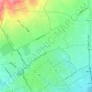
Name: El Bassatine topographic map, elevation, terrain.
Location: El Bassatine, Délégation Mnihla, Gouvernorat Ariana, Tunisie (36.83974 10.09030 36.85157 10.10934)
Average elevation: 285 ft
Minimum elevation: 161 ft
Maximum elevation: 541 ft
Other topographic maps
Click on a map to view its topography, its elevation and its terrain.
La Soukra
Tunisie > Gouvernorat Ariana > El Bassatine
La Soukra, El Bassatine, Délégation Soukra, Gouvernorat Ariana, 2036, Tunisie
Average elevation: 10 ft