
Krakau topographic map
Interactive map
Click on the map to display elevation.
About this map
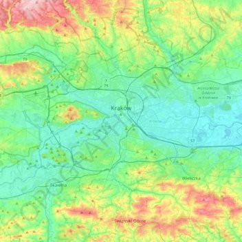
Name: Krakau topographic map, elevation, terrain.
Location: Krakau, powiat wielicki, Woiwodschaft Kleinpolen, Polen (49.96767 19.79224 50.12613 20.21735)
Average elevation: 846 ft
Minimum elevation: 614 ft
Maximum elevation: 1,499 ft
Die Wawelanhöhe, auf der das Schloss und die Kathedrale stehen, wurde bereits vor 20.000 Jahren besiedelt. In der Nähe von Krakau bauten die Menschen bereits in prähistorischen Zeiten Salz ab und handelten damit.
Other topographic maps
Click on a map to view its topography, its elevation and its terrain.
Groß Salze
Polen > Woiwodschaft Kleinpolen > powiat wielicki > Groß Salze
Groß Salze, gmina Wieliczka, powiat wielicki, Woiwodschaft Kleinpolen, 32-020, Polen
Average elevation: 886 ft