
Villa de Álvarez topographic map
Interactive map
Click on the map to display elevation.
About this map
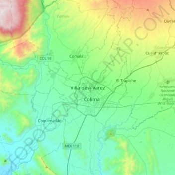
Name: Villa de Álvarez topographic map, elevation, terrain.
Location: Villa de Álvarez, Colima, 28987, México (19.10514 -103.89601 19.42514 -103.57601)
Average elevation: 2,326 ft
Minimum elevation: 597 ft
Maximum elevation: 7,913 ft
Other topographic maps
Click on a map to view its topography, its elevation and its terrain.
Juluapan
México > Colima > Villa de Álvarez
Juluapan, Villa de Álvarez, Colima, 28959, México
Average elevation: 1,808 ft