
Tenneville topographic map
Interactive map
Click on the map to display elevation.
About this map
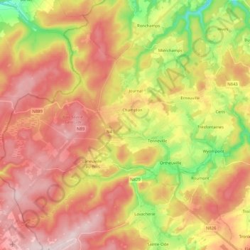
Name: Tenneville topographic map, elevation, terrain.
Location: Tenneville, Marche-en-Famenne, Luxembourg, Wallonia, Belgium (50.04780 5.39024 50.15146 5.59735)
Average elevation: 1,457 ft
Minimum elevation: 863 ft
Maximum elevation: 1,932 ft
Other topographic maps
Click on a map to view its topography, its elevation and its terrain.
Bende
Belgium > Luxembourg > Marche-en-Famenne > Durbuy
Bende, Durbuy, Marche-en-Famenne, Luxembourg, Wallonia, Belgium
Average elevation: 817 ft
Durbuy
Belgium > Luxembourg > Marche-en-Famenne > Durbuy
Durbuy, Marche-en-Famenne, Luxembourg, Wallonia, 6940, Belgium
Average elevation: 728 ft
Marche-en-Famenne
Belgium > Luxembourg > Marche-en-Famenne > Marche-en-Famenne
Marche-en-Famenne, Luxembourg, Wallonia, 6900, Belgium
Average elevation: 827 ft
Hargimont
Belgium > Luxembourg > Marche-en-Famenne > Marche-en-Famenne
Hargimont, Marche-en-Famenne, Luxembourg, Wallonia, 6900, Belgium
Average elevation: 879 ft
Heyd
Belgium > Luxembourg > Marche-en-Famenne > Durbuy
Heyd, Durbuy, Marche-en-Famenne, Luxembourg, Wallonia, Belgium
Average elevation: 853 ft
Mousny
Belgium > Luxembourg > Marche-en-Famenne
Mousny, Ortho, La Roche-en-Ardenne, Marche-en-Famenne, Luxembourg, Wallonia, 6983, Belgium
Average elevation: 1,289 ft
Marche-en-Famenne
Belgium > Luxembourg > Marche-en-Famenne
Marche-en-Famenne, Luxembourg, Wallonia, 6900, Belgium
Average elevation: 886 ft