
St. Margaret's at Cliffe topographic map
Interactive map
Click on the map to display elevation.
About this map
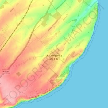
Name: St. Margaret's at Cliffe topographic map, elevation, terrain.
Location: St. Margaret's at Cliffe, Dover, Kent, England, United Kingdom (51.13074 1.33161 51.18042 1.40213)
Average elevation: 174 ft
Minimum elevation: 0 ft
Maximum elevation: 410 ft
Other topographic maps
Click on a map to view its topography, its elevation and its terrain.
Sandwich Bay
United Kingdom > England > Kent > Dover
Sandwich Bay, Dover, Kent, England, CT13 9PZ, United Kingdom
Average elevation: 3 ft
Claypits
United Kingdom > England > Kent > Dover > Goodnestone
Claypits, Goodnestone, Dover, Kent, England, CT3 1PB, United Kingdom
Average elevation: 112 ft
Richborough
United Kingdom > England > Kent > Dover
Richborough, Dover, Kent, England, CT13 9JH, United Kingdom
Average elevation: 13 ft
River
United Kingdom > England > Kent > Dover
River, Dover, Kent, England, United Kingdom
Average elevation: 262 ft