
Blankenfelde topographic map
Interactive map
Click on the map to display elevation.
About this map
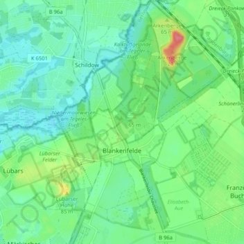
Name: Blankenfelde topographic map, elevation, terrain.
Location: Blankenfelde, Pankow, Berlin, 13159, Deutschland (52.60010 13.36691 52.64829 13.43288)
Average elevation: 164 ft
Minimum elevation: 98 ft
Maximum elevation: 328 ft
Other topographic maps
Click on a map to view its topography, its elevation and its terrain.
Volkspark Prenzlauer Berg
Deutschland > Berlin > Pankow
Volkspark Prenzlauer Berg, Prenzlauer Berg, Pankow, Berlin, 10407, Deutschland
Average elevation: 180 ft