
Grotte topographic map
Interactive map
Click on the map to display elevation.
About this map
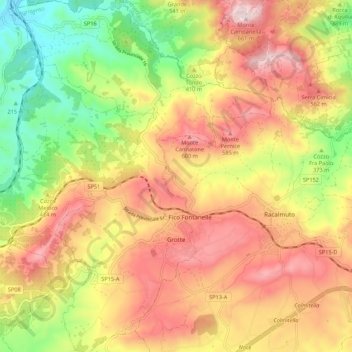
Name: Grotte topographic map, elevation, terrain.
Location: Grotte, Agrigento, Sicily, 92020, Italy (37.37526 13.64911 37.46114 13.73051)
Average elevation: 1,342 ft
Minimum elevation: 446 ft
Maximum elevation: 2,162 ft
Other topographic maps
Click on a map to view its topography, its elevation and its terrain.
Palma di Montechiaro
Palma di Montechiaro, Agrigento, Sicily, 92020, Italy
Average elevation: 453 ft
Lucca Sicula
Lucca Sicula, Agrigento, Sicily, 92010, Italy
Average elevation: 945 ft