
Lower Township topographic map
Interactive map
Click on the map to display elevation.
About this map
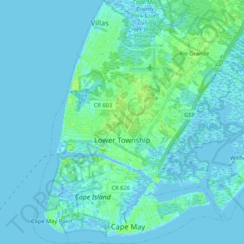
Name: Lower Township topographic map, elevation, terrain.
Location: Lower Township, Cape May County, New Jersey, United States (38.92547 -74.97771 39.03926 -74.83087)
Average elevation: 7 ft
Minimum elevation: -16 ft
Maximum elevation: 36 ft
Other topographic maps
Click on a map to view its topography, its elevation and its terrain.
North Cape May
United States > New Jersey > Cape May County > Lower Township > North Cape May
North Cape May, Lower Township, Cape May County, New Jersey, 08204, United States
Average elevation: 7 ft
Lower Township
United States > New Jersey > Cape May County > Lower Township
Lower Township, Cape May County, New Jersey, 08204, United States
Average elevation: 10 ft