
North Kingstown topographic map
Interactive map
Click on the map to display elevation.
About this map
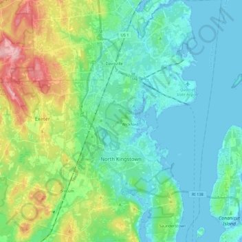
Name: North Kingstown topographic map, elevation, terrain.
Location: North Kingstown, South County, Rhode Island, United States (41.49719 -71.52280 41.65453 -71.40206)
Average elevation: 115 ft
Minimum elevation: -23 ft
Maximum elevation: 476 ft
Other topographic maps
Click on a map to view its topography, its elevation and its terrain.
Westerly
United States > Rhode Island > South County
Westerly, South County, Rhode Island, 02808, United States
Average elevation: 62 ft
South Kingstown
United States > Rhode Island > South County
South Kingstown, South County, Rhode Island, United States
Average elevation: 98 ft
Charlestown
United States > Rhode Island > South County
Charlestown, South County, Rhode Island, 02813, United States
Average elevation: 72 ft
Wakefield
United States > Rhode Island > South County > South Kingstown
Wakefield, South Kingstown, South County, Rhode Island, 02879, United States
Average elevation: 75 ft
Narragansett Town Beach
United States > Rhode Island > South County > Narragansett > Narragansett Pier
Narragansett Town Beach, Narragansett Beach, Narragansett Pier, Narragansett, South County, Rhode Island, United States
Average elevation: 20 ft
Green Hill Point
United States > Rhode Island > South County > South Kingstown > Green Hill
Green Hill Point, Green Hill, South Kingstown, South County, Rhode Island, United States
Average elevation: 7 ft
Block Island
United States > Rhode Island > South County > New Shoreham
Block Island, New Shoreham, South County, Rhode Island, 02807, United States
Average elevation: 16 ft
Narragansett
United States > Rhode Island > South County
Narragansett, South County, Rhode Island, 02882, United States
Average elevation: 39 ft
Newton Swamp Management Area
United States > Rhode Island > South County > Westerly
Newton Swamp Management Area, McGowan Corners, Westerly, South County, Rhode Island, 02808, United States
Average elevation: 72 ft
Kingston
United States > Rhode Island > South County
Kingston, South County, Rhode Island, 02881, United States
Average elevation: 154 ft
Ashaway
United States > Rhode Island > South County > Hopkinton > Ashaway
Ashaway, Hopkinton, South County, Rhode Island, 02804, United States
Average elevation: 102 ft
Saunderstown
United States > Rhode Island > South County > North Kingstown
Saunderstown, North Kingstown, South County, Rhode Island, 02874, United States
Average elevation: 46 ft
Exeter
United States > Rhode Island > South County
Exeter, South County, Rhode Island, 02822, United States
Average elevation: 184 ft
Hope Valley
United States > Rhode Island > South County > Hopkinton > Hope Valley
Hope Valley, Hopkinton, South County, Rhode Island, 02832, United States
Average elevation: 180 ft
Hopkinton
United States > Rhode Island > South County
Hopkinton, South County, Rhode Island, United States
Average elevation: 207 ft
Indian Lake
United States > Rhode Island > South County > South Kingstown
Indian Lake, South Kingstown, South County, Rhode Island, United States
Average elevation: 105 ft
Wickford
United States > Rhode Island > South County > North Kingstown > Wickford
Wickford, North Kingstown, South County, Rhode Island, 02852, United States
Average elevation: 39 ft
Matunuck
United States > Rhode Island > South County > South Kingstown
Matunuck, South Kingstown, South County, Rhode Island, United States
Average elevation: 16 ft
New Shoreham
United States > Rhode Island > South County
New Shoreham, South County, Rhode Island, 02807, United States
Average elevation: 16 ft
Richmond
United States > Rhode Island > South County
Richmond, South County, Rhode Island, United States
Average elevation: 184 ft