
Plainfield topographic map
Interactive map
Click on the map to display elevation.
About this map
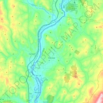
Name: Plainfield topographic map, elevation, terrain.
Location: Plainfield, Sullivan County, New Hampshire, United States (43.48894 -72.39644 43.60027 -72.17117)
Average elevation: 876 ft
Minimum elevation: 276 ft
Maximum elevation: 2,385 ft
Other topographic maps
Click on a map to view its topography, its elevation and its terrain.
Mill Hollow
United States > New Hampshire > Sullivan County > Plainfield > Mill Hollow
Mill Hollow, Plainfield, Sullivan County, New Hampshire, 03770, United States
Average elevation: 1,027 ft