
Blair topographic map
Interactive map
Click on the map to display elevation.
About this map
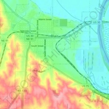
Name: Blair topographic map, elevation, terrain.
Location: Blair, Washington County, Nebraska, United States (41.50904 -96.16512 41.56189 -96.09471)
Average elevation: 1,125 ft
Minimum elevation: 978 ft
Maximum elevation: 1,378 ft
Other topographic maps
Click on a map to view its topography, its elevation and its terrain.
Fort Calhoun
United States > Nebraska > Washington County
Fort Calhoun, Washington County, Nebraska, 68023, United States
Average elevation: 1,106 ft
Herman
United States > Nebraska > Washington County
Herman, Washington County, Nebraska, United States
Average elevation: 1,050 ft