
Machida topographic map
Interactive map
Click on the map to display elevation.
About this map
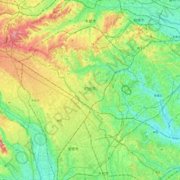
Name: Machida topographic map, elevation, terrain.
Location: Machida, Tokyo, Japan (35.50122 139.26880 35.62350 139.50742)
Average elevation: 266 ft
Minimum elevation: 23 ft
Maximum elevation: 712 ft
Machida is located in the Tama Hills of southern Tokyo Metropolis, bordered by Kanagawa Prefecture on the west, south, and east approximately 40 to 50 kilometers from the center of Tokyo. The highest point is Mount Kusato (elevation 364 meters) at the western end. There are few flatlands near Machida Station, the Sakai River flows to the west and south, and the Tsurumi River flows almost in the center of the city.
Other topographic maps
Click on a map to view its topography, its elevation and its terrain.
Ozora
Ozora, Abashiri County, Okhotsk Subprefecture, Hokkaido Prefecture, Japan
Average elevation: 371 ft
Biratori
Biratori, Saru County, Hidaka Subprefecture, Hokkaido Prefecture, Japan
Average elevation: 607 ft
Toshima Island
Toshima Island, Maizuru, Kyoto Prefecture, Japan
Average elevation: 69 ft
Niseko
Niseko, Abuta County, Shiribeshi Subprefecture, Hokkaido Prefecture, Japan
Average elevation: 1,112 ft
Nichinan
Nichinan, Hino County, Tottori Prefecture, Japan
Average elevation: 1,906 ft
Noto
Noto, Houshi County, Ishikawa Prefecture, Chubu Region, Japan
Average elevation: 184 ft
Kitanakagusuku
Kitanakagusuku, Nakagami, Okinawa Prefecture, Japan
Average elevation: 194 ft
Watarase Usuichi
Watarase Usuichi, Tochigi, Tochigi Prefecture, 374-0112, Japan
Average elevation: 59 ft
Minakami
Minakami, Tone County, Gunma Prefecture, Japan
Average elevation: 3,350 ft
Saza
Saza, Kita-Matsuura County, Nagasaki Prefecture, 857-0322, Japan
Average elevation: 364 ft
Arita
Arita, Nishi-Matsuura County, Saga Prefecture, Japan
Average elevation: 604 ft
Sagara
Sagara, Kuma County, Kumamoto Prefecture, 868-0094, Japan
Average elevation: 1,385 ft
Nakaniikawa County
Nakaniikawa County, Toyama Prefecture, Chubu Region, Japan
Average elevation: 2,182 ft
Furuu County
Furuu County, Shiribeshi Subprefecture, Hokkaido Prefecture, Japan
Average elevation: 407 ft
Ashigarashimo County
Ashigarashimo County, Kanagawa Prefecture, Japan
Average elevation: 1,056 ft
Manazuru
Manazuru, Ashigarashimo County, Kanagawa Prefecture, 259-0201, Japan
Average elevation: 676 ft