
Fhain topographic map
Interactive map
Click on the map to display elevation.
About this map
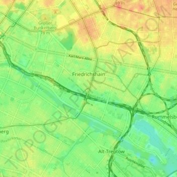
Name: Fhain topographic map, elevation, terrain.
Location: Fhain, Friedrichshain-Kreuzberg, Berlin, Germany (52.48605 13.41975 52.53103 13.49144)
Average elevation: 141 ft
Minimum elevation: 72 ft
Maximum elevation: 213 ft
Other topographic maps
Click on a map to view its topography, its elevation and its terrain.
Friedrichshain-Kreuzberg
Friedrichshain-Kreuzberg, Berlin, Germany
Average elevation: 148 ft
Charlottenburg-Wilmersdorf
Charlottenburg-Wilmersdorf, Berlin, Germany
Average elevation: 144 ft
Schöneberg
Schöneberg, Tempelhof-Schöneberg, Berlin, Germany
Average elevation: 151 ft